 Mohamed Ali CHERIF

See more details on :
http://bigalltoday.wix.com/topnavette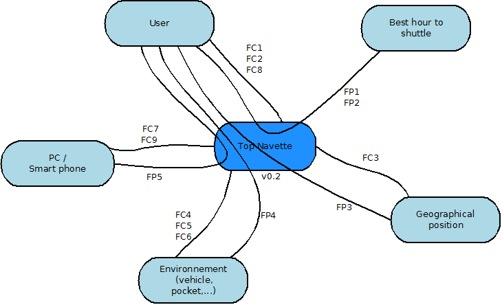
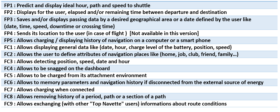
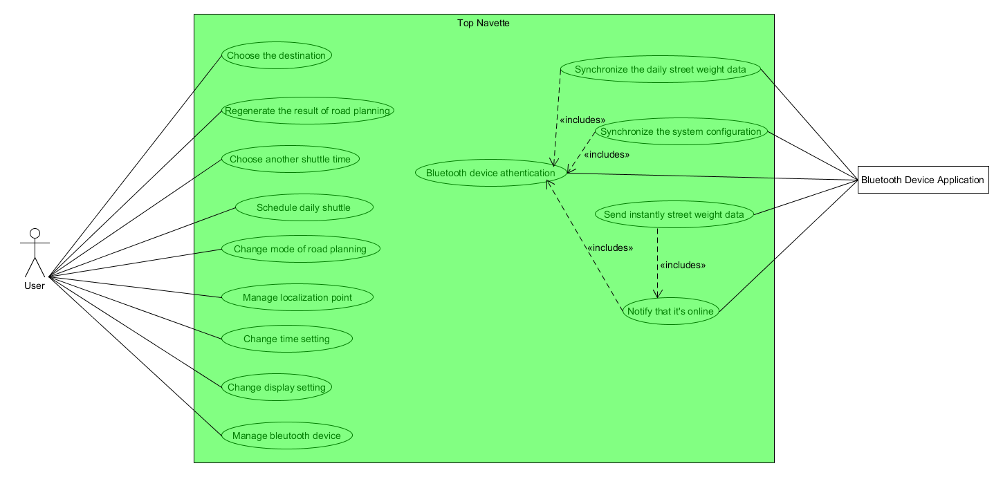
| Service Functions | Criterion | Level | Acceptance limit | Flexibility |
| FP1 | The display is done by a screen | -- | -- | F0 |
| The optimization is depending on the set of 3 parameters: time, speed and path | -- | -- | F1 | |
| The optimization is generated according to one selectable parameter: time, speed or shortest path | -- | -- | F1 | |
| The optimization is generated for a selected period or stretch | -- | -- | F0 | |
| A selected period or section can be excluded from the optimization | -- | -- | F0 | |
| The user can select the appropriate algorithm of optimization | -- | -- | F2 | |
| Number of optimization algorithms | 3 | +-1 | F2 | |
| A non suitable optimized value can be rejected by the user | -- | -- | F2 | |
| The settings of optimization set by the user are stored | -- | -- | F0 | |
| A path is defined by a starting position, arrival position and two intermediate points (3 sections) | -- | -- | F1 | |
| Number of intermediate points in a path | 2 points | +1 -0 | F1 | |
| By default the system does not save the intermediate points (except when selected by the user) | -- | -- | F1 | |
| Possibility to nominate any desired path and its intermediate points | -- | -- | F0 | |
| Number of characters for the nomination | 16 caract. | +-2 | F1 | |
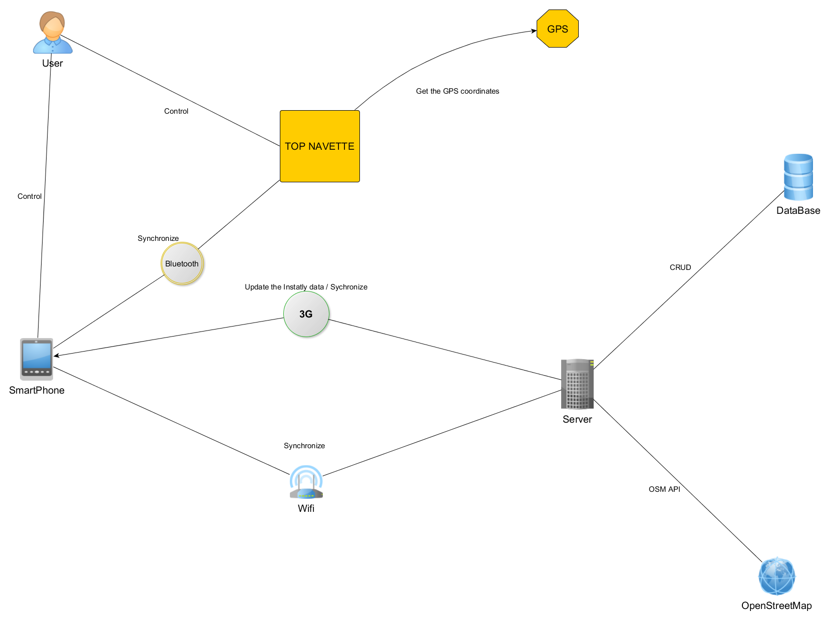
| The optimized data can be sent (on a GSM or PC) when requested by the user | -- | -- | F1 | |
| Minimum distance for data emission | 200 m | -30 m | F1 | |
| FP2 | Displaying the elapsed time | -- | -- | F0 |
| Displaying the remaining time | -- | -- | F0 | |
| Displaying the arriving time | -- | -- | F3 | |
| Choosing which parameter (arriving, elapsed, remaining time) to display | -- | -- | F1 | |
| Estimation is based on the real road state (but can be also estimated from the user's navigation history, if real road state informations does not exist) | -- | -- | F1 | |
| FP3 | Displaying saved parameters for a specified date and/or hour and/or period | -- | -- | F0 |
| Displaying saved parameters for a specified geographical zone | -- | -- | F0 | |
| Displaying saved parameters for a specified (geographical zone and date) | -- | -- | F0 | |
| Saving parameters for specified zone that is defined by the user | -- | -- | F0 | |
| The zone delimitation is done by pressing a button when entering and leaving the zone or by entering its coordinates | -- | -- | F1 | |
| Saving navigation data for specified date and/or hour and/or period that can be visited in the future | -- | -- | F0 | |
| Removing data is protected by a password | -- | -- | F0 | |
| FP4 | Response type | SMS | -- | F2 |
| Data contained in the response | Coordinates Date, H, Speed… | -- | F0 | |
| Launching of saving data for the crossed routes | -- | -- | F0 | |
| Response of the request of "FP4" is protected by the user's password | -- | -- | F0 | |
| This part of the system (that detects and send position to user) is hidden in the vehicle and is separated from the "Top Navette" displying screen | -- | -- | F0 | |
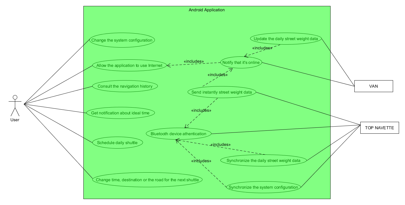
| FP5 | The method of connection between the system and the PC | SD memory/ USB/Wifi / Bluetooth | -- | F3 |
| A simple application allows to load/save data from/on PC | -- | -- | F3 | |
| FC1 | The choice of displaying screen by the user | -- | -- | F1 |
| FC2 | Possibility to nominate paths | -- | -- | F0 |
| The definition of a path can be done by entering its coordinates or by pressing a button when crossing the desired zone | -- | -- | F0 | |
| FC6 | Minimum hold time after cutting off the external power | 3 days | -- | F0 |
| FC9 | Personal navigation data is absolutely preserved, the information exchanged are those concerning road conditions, such as : length, fluidity (depending on date), caps, … | -- | -- | F0 |
| F0 : Null flexibility, imperative level | ||||
| F1 : Low flexibility, a slightly negotiable level | ||||
| F2 : Good flexibility, negotiable level if there is a compensation | ||||
| F3 : High flexibility, negotiable level |

 Nadine
 PointyOintment
 Rohan Menon
 dannyvai